


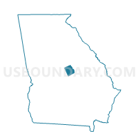
31904 - HIGH HILL Voting District, Wilkinson County, Georgia
About
Outline

Summary
| Unique Area Identifier | 563163 |
| Name | 31904 - HIGH HILL Voting District |
| County | Wilkinson County |
| State | Georgia |
| Area (square miles) | 46.70 |
| Land Area (square miles) | 46.56 |
| Water Area (square miles) | 0.14 |
| % of Land Area | 99.70 |
| % of Water Area | 0.30 |
| Latitude of the Internal Point | 32.71242090 |
| Longtitude of the Internal Point | -83.17607240 |
Maps


Graphs
Select a template below for downloading or customizing gragh for 31904 - HIGH HILL Voting District, Wilkinson County, Georgia


Neighbors
Neighoring Voting District (by Name) Neighboring Voting District on the Map
- 289JV/W - JEFFERSONVILLE Voting District, Twiggs County, GA
- 31903 - GRIFFIN Voting District, Wilkinson County, GA
- 31905 - IRWINTON Voting District, Wilkinson County, GA
- 31907 - LORD Voting District, Wilkinson County, GA
- 31911 - TURKEY CREEK Voting District, Wilkinson County, GA
Top 10 Neighboring County Subdivision (by Population) Neighboring County Subdivision on the Map
- North Twiggs CCD, Twiggs County, GA (5,072)
- Irwinton CCD, Wilkinson County, GA (3,319)
- Allentown CCD, Wilkinson County, GA (983)
- Toomsboro CCD, Wilkinson County, GA (941)
Top 10 Neighboring Unified School District (by Population) Neighboring Unified School District on the Map
Top 10 Neighboring State Legislative District Lower Chamber (by Population) Neighboring State Legislative District Lower Chamber on the Map
Top 10 Neighboring State Legislative District Upper Chamber (by Population) Neighboring State Legislative District Upper Chamber on the Map
Top 10 Neighboring 111th Congressional District (by Population) Neighboring 111th Congressional District on the Map
Top 10 Neighboring Census Tract (by Population) Neighboring Census Tract on the Map
- Census Tract 601, Twiggs County, GA (5,072)
- Census Tract 9602, Wilkinson County, GA (3,319)
- Census Tract 9604, Wilkinson County, GA (1,924)